Review of MD Heights (MD)
Another hiking guide! Wahoo!
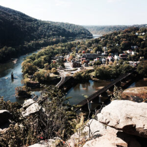
My boyfriend and I decided to take a spontaneous trip to Maryland Heights; the highest mountain overlooking Harpers Ferry in VA. It’s located in Maryland near the border of Virginia and West Virginia.
The top of this mountain has a breathtaking 300-foot vertical cliff that towers over the Potomac River, the Ohio Canal, Chesapeake Canal, Ohio and Baltimore railroad.
I wanted to go over my experience and some background information if you ever decide to hike this beautiful view one day!
History
Maryland heights are momentous in Civil War history. This mountain hosted the first military fight between Confederate and Union troops in the state of Maryland.
This mountain was the most critical and significant target of the Confederate army in the Battle of Harper’s Ferry which lasted a couple of days in 1862. Maryland heights were occupied most of the war by U.S. forces.
 There was a monumental moment that Maryland Heights is known for, which is that the armed forces halted a 100-pounder Parrorr Rifle that could hurt a 100-pound shell more than two miles. This canon weighed nearly ten tons and was carried all the way up the mountain of Maryland Heights.
Maryland heights played a major role in the confederacy’s third and final invasion of the North. Without this event happening, Maryland Heights would be the attraction that it is today!
The Hike
Parking

Let’s start with parking. There are multiple places to park, but the best place is at the entrance of the hike near Sandy Hook Road to avoid a $10 fee for parking. This parking spot also has a beautiful view of the Potomac River right next to it.
Difficulty
This hike does take quite a bit of strength. I would say the steepness of the mountain varies from moderate to difficult with an elevation gain of 1600 feet.
On a scale of 1-5 for difficulty, I would give it a 3 for the uphill portion.

Getting to the mountain is ALL uphill, but that means, getting down from the hike is ALL downhill! The way down is A LOT faster than the way up.
Setting
There are lots of cobblestones, so please be super aware of that. It is easy to misplace your step. If you’re going on a rainy day, wearing hiking shoes to prevent slippage on the cobblestone.
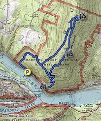
There are two paths you can take: one of the paths takes an hour and a half, up to the top of the mountain and back. The other trail takes up to three hours if you love hiking, this is the one for you. 
Along the hike, you can see many civil war forts, trenches, encampments, and ruins. It made me super appreciative of my life with beautiful scenery, with a massive historical background.
Final thoughts
Overall, this is an enjoyable hike with a beautiful view mixed with a historical background. I would recommend it to those looking for a scenic hike around the Baltimore-Washington Metropolitan Area. 


